ABOUT AGULO
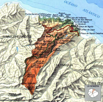
The municipality of Agulo covers 2,539 hectares and more than 30% of its territory is located within Garajonay National Park. This is its most elevated part of the municipality, located above 800 metres, occupied by La Gomera’s laurisilva forest.
The historical uses of mountain resources is quite complex, most of all because its forest has always been under some kind of administration and has always been considered a strategic resource. From the epoch of the condes to the municipal governments, the state administration, or the arrival, in the 1970s, of ICONA (Nature Conservation Institute).
In 1981 Garajonay was declared a national park, the most recent in the Canaries, consolidating the protection of this important resource for La Gomera and its inhabitants. The island has the most well-known example of laurisilva, an ecosystem from the Cenozoic Era, which disappeared from the European continent due to climate changes that occurred in the Quaternary.
THE MUNICIPALITY OF AGULO
At the start of the 15th Century, different European expeditions reached the coasts of La Gomera. The Portuguese, sent by Prince Henry the Navigator, reached the northern half of the island and lived alongside the ancient Gomerans for 30 years and began converting them to Christianity.
Pre-Hispanic La Gomera was divided into four cantons: Orone, Ipalán, Agana and Mulagua, which belonged to the territory that is today Agulo. After control of the territory was passed to the Crown of Castile, the municipality was founded in 1607 when the lords of La Gomera and El Hierro granted land to colonists from Buenavista del Norte (Tenerife) in the area of Sobreagulo and San Marcos.


